
Alexandria residents can weigh in on 25-year National Capital Region Transportation Plan
Regional plan includes new rail capacity through city but forecasts worsening traffic delays

Alexandria residents have until Nov. 21 to weigh in on a 25-year transportation plan that will shape how people move through the Washington region, including changes to transit, roadways, and rail infrastructure that directly affect the city.
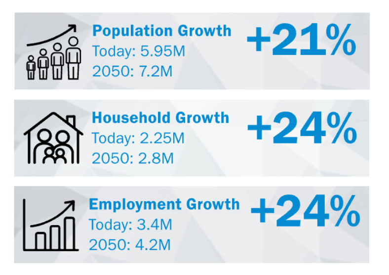
The National Capital Region Transportation Planning Board opened a public comment period Tuesday for Visualize 2050, the federally required update to the region’s long-range transportation plan. The plan projects the region will add 1.2 million residents and 800,000 jobs by 2050 and outlines how transportation infrastructure across Washington, suburban Maryland, and Northern Virginia will accommodate that growth.
What It Means for Alexandria
The draft plan includes infrastructure projects that affect Alexandria, although the executive summary does not detail all city-specific projects. Two rail infrastructure improvements mentioned are the New Long Bridge over the Potomac River and the Alexandria Fourth Railroad Track project, which extends from south of the George Washington Parkway to south of Telegraph Road. These projects aim to increase freight and passenger rail capacity, thereby easing bottlenecks along the East Coast rail corridor.
Regionwide, the plan calls for modest roadway expansion — adding 600 lane miles to the current 17,000 lane miles, a 3% increase. Bus rapid transit is expected to grow significantly, from 14 lane miles and 28 stations to 93 lane miles and 118 stations by 2050.
How Travel Patterns May Change
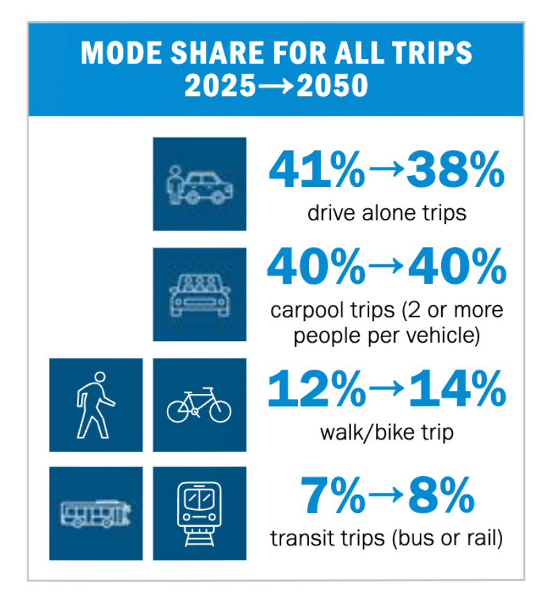
The plan forecasts shifts in how people travel. Walking, biking, and transit trips are expected to increase from 19% to 22% of all trips regionwide by 2050, while drive-alone trips are projected to decline from 41% to 38%. Carpooling is expected to remain steady at about 40% of all trips.
By 2050, more residents and jobs will concentrate near the region’s 145 Regional Activity Centers and within a half-mile of high-capacity transit stations. The number of high-capacity transit stations within activity centers is projected to increase from 148 to 246.
For Alexandria residents, this could mean improved access to jobs by transit — the plan projects a 16% increase in job accessibility by transit regionwide due to expanded high-capacity transit and growing job concentrations near stations.
Congestion Trade-offs
The plan acknowledges a significant challenge: despite investments, traffic delays are forecast to increase. Average delay per trip is expected to rise from 4.1 minutes to 5.9 minutes — a 44% increase. However, the plan notes that without these investments, job accessibility by car would decline by 11% instead of the projected 5%.
The plan also notes that while total vehicle miles traveled will increase due to growth, the average resident is expected to travel five percent fewer miles by automobile, as some residents travel shorter distances.
Funding Reality
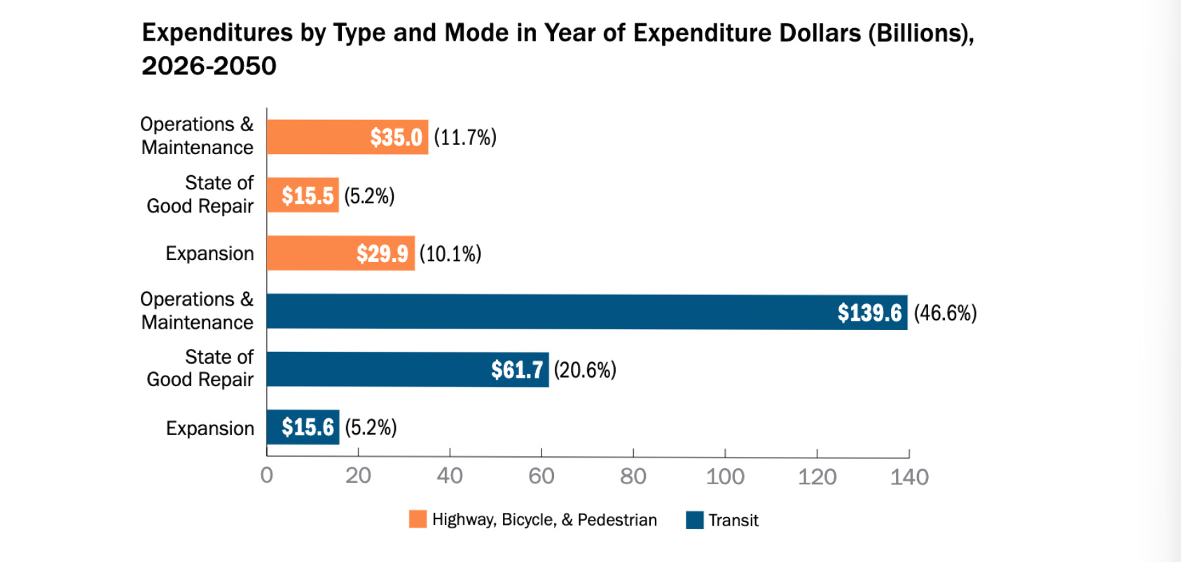
The plan anticipates $299 billion in transportation spending from 2026 through 2050, with 85% of the funds dedicated to operating and maintaining existing infrastructure. Only 15% will be available for system expansion.
Most funding will come from state sources (51%), followed by local funds (18%), federal funds (14%), fares and tolls (14%), and private sources (2%).
The plan identifies “insufficient transit revenue to sustain, let alone increase services” as a future challenge, noting “financial uncertainties will hinder the region’s ability to elevate the transit system to a world-class modern standard.”
Environmental Projections
The plan projects that on-road vehicle emissions will decline through 2050 as electric vehicles and cleaner, more efficient vehicles replace older models. The region’s transportation improvements are expected to meet federal air quality standards for ozone.
Many projects will incorporate features to strengthen transportation system resilience, with road and bridge upgrades better equipped to withstand flooding and new transit and pedestrian infrastructure providing safer options during extreme heat.
What Comes Next
The Transportation Planning Board is also seeking input on two related documents: the FY 2026-2029 Transportation Improvement Program, a four-year blueprint of projects that will receive federal, state, local, and other funding, and an Air Quality Conformity Analysis Report.
Comments can be submitted through Nov. 21 at visualize2050.org. The Transportation Planning Board plans to review and take action on the plan this fall.