
Regional officials briefed on Potomac sewage crisis. The Virginia data tells a more specific story for Alexandria.
Monday's COG meeting confirmed the broad outlines of the response. A review of state agency websites shows what's happening on this side of the river.

More than 170 people joined a virtual briefing on Monday, convened by the Metropolitan Washington Council of Governments (COG) on the Potomac Interceptor sewer collapse, including several COG Board members, agency staff, and members of the public. The 90-minute session was the first regional public accounting of a crisis now in its sixth week. COG Board Vice Chair Mayor Alyia Gaskins was among those present.
For readers coming to this story fresh: on January 19 — Martin Luther King Jr. Day — a 72-inch sewer pipe collapsed near the Clara Barton Parkway and I-495 interchange in Montgomery County, Maryland, releasing raw sewage into the Potomac River. The pipe is part of the 54-mile Potomac Interceptor, built in the early 1960s, which carries wastewater from Loudoun and Fairfax counties, the Dulles corridor, and parts of Montgomery County to DC Water’s Blue Plains treatment plant. It serves more than 500,000 people, including Alexandria residents. DC Water activated an emergency bypass five days after the collapse, but by then, approximately 194 million gallons had already reached the river. Additional smaller overflows followed. The total stands at approximately 243.5 million gallons.
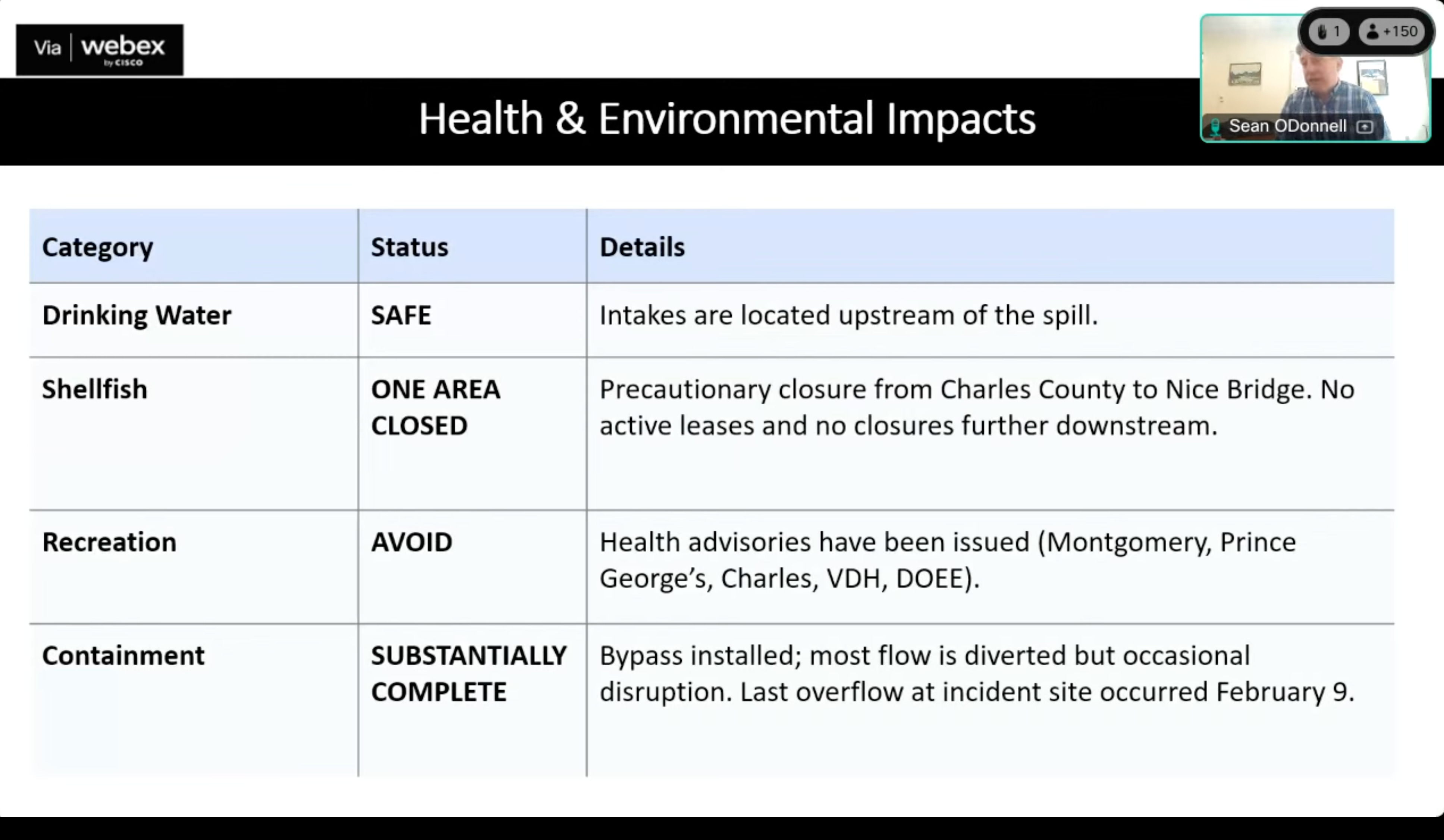
Officials confirmed Monday that pipe repairs are on track for mid-March. The emergency bypass is holding with more than 130 million gallons per day of pumping capacity. The last overflow reaching the river occurred on February 8. Drinking water is safe — all active intakes are upstream of the spill. Washington Aqueduct plant operations chief Nina Hallise was unambiguous: “No contaminated water ever even came to either plant.”
The Virginia Department of Health’s recreational water advisory — issued February 13 and covering 72.5 miles of the Potomac from the American Legion Bridge in Fairfax County to the Route 301 Bridge in King George County — remains in effect. It will not be lifted until sustainable repairs are complete. Alexandria’s waterfront falls within that zone.
What the Virginia data shows
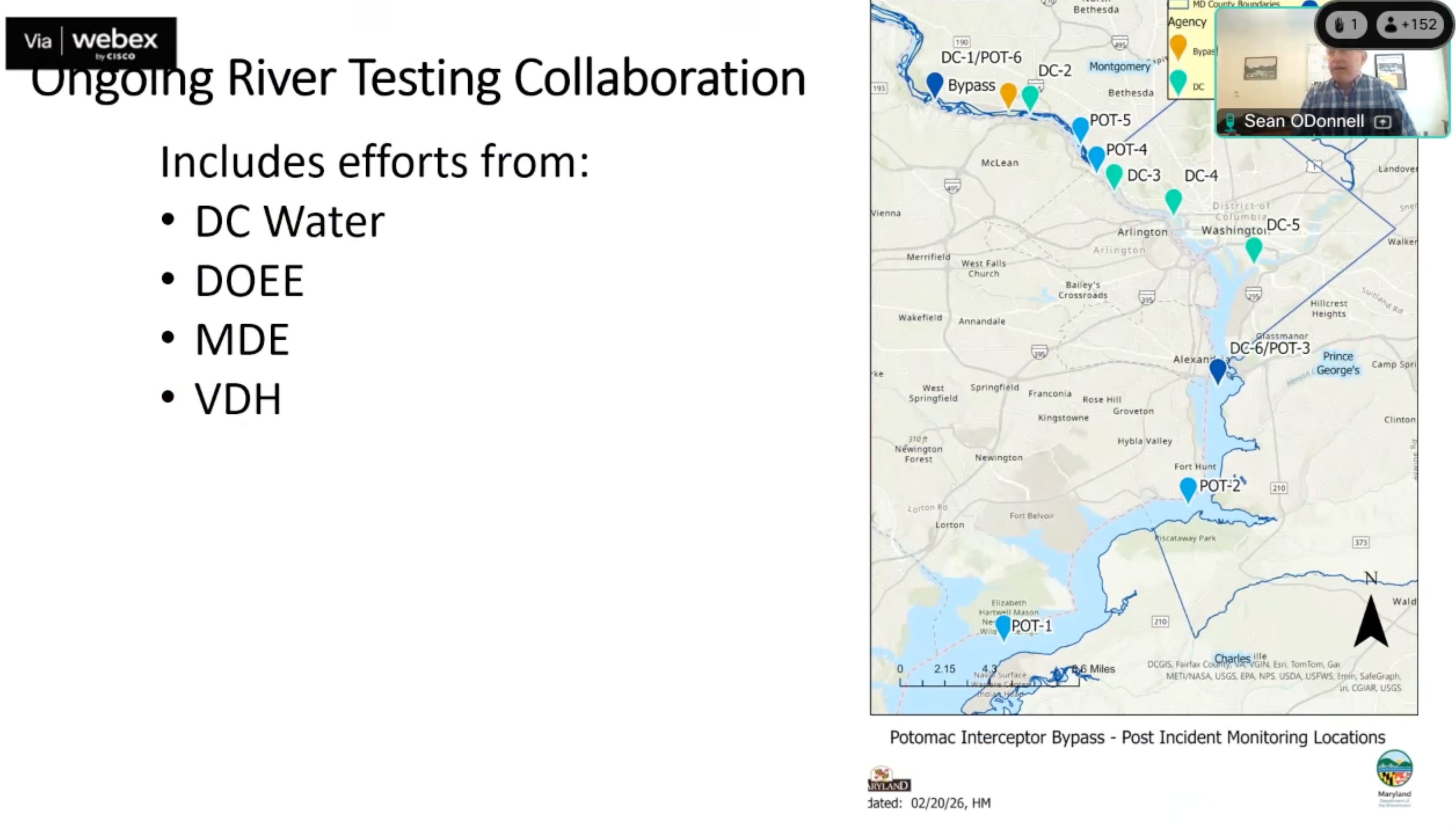
Monday’s presentations drew primarily on DC Water’s daily monitoring network and DC’s Department of Energy and Environment, whose sampling locations are all on the Maryland or DC side of the river. After the briefing, I reviewed what Virginia’s own agencies have published.
On February 17, Virginia DEQ conducted a special round of bacteria sampling at 25 locations along approximately 49 miles of Virginia’s Potomac shoreline, from Chain Bridge to Potomac Creek. DEQ Director Mike Rolband, who attended Monday’s briefing, posted a link to the results in the chat. The data was not presented during the session.
The results show elevated bacteria readings across the northern Virginia shoreline — the stretch closest to the spill site — with levels generally returning to background as you move south toward Quantico and beyond.
For Alexandria specifically:
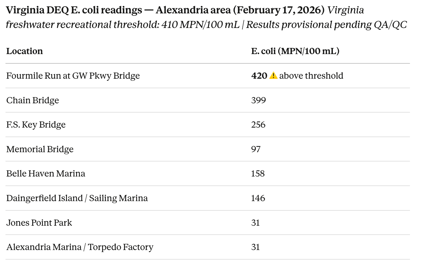
Fourmile Run at the George Washington Parkway Bridge was the only Virginia-side location in DEQ’s dataset to exceed the 410 threshold. The margin is modest, and the results are provisional. The more severe contamination remains concentrated near the overflow site in Montgomery County, where DC Water’s daily monitoring has recorded readings as high as 730,000 MPN — nearly 1,800 times the threshold. But the DEQ data confirms the spill may have measurably reached Alexandria-area waters.
DEQ also measured enterococci, which Virginia uses as the standard for transitional and saltwater areas near Quantico and downstream. Several northern Virginia locations showed elevated readings on February 17, including Fourmile Run (450 CFU/100 mL), Daingerfield Island (470), and Dogue Creek in Fairfax (550) — all above Virginia’s 130 CFU threshold for those water types. These are freshwater locations where E. coli is the primary standard, so the enterococci figures are supplementary, but the pattern is consistent with contamination working downstream from the spill.
Further south, readings drop sharply. Neabsco Creek in Prince William, Quantico Creek, Powells Creek, and the Occoquan River all came back below detection limits on February 17.
The shellfish picture
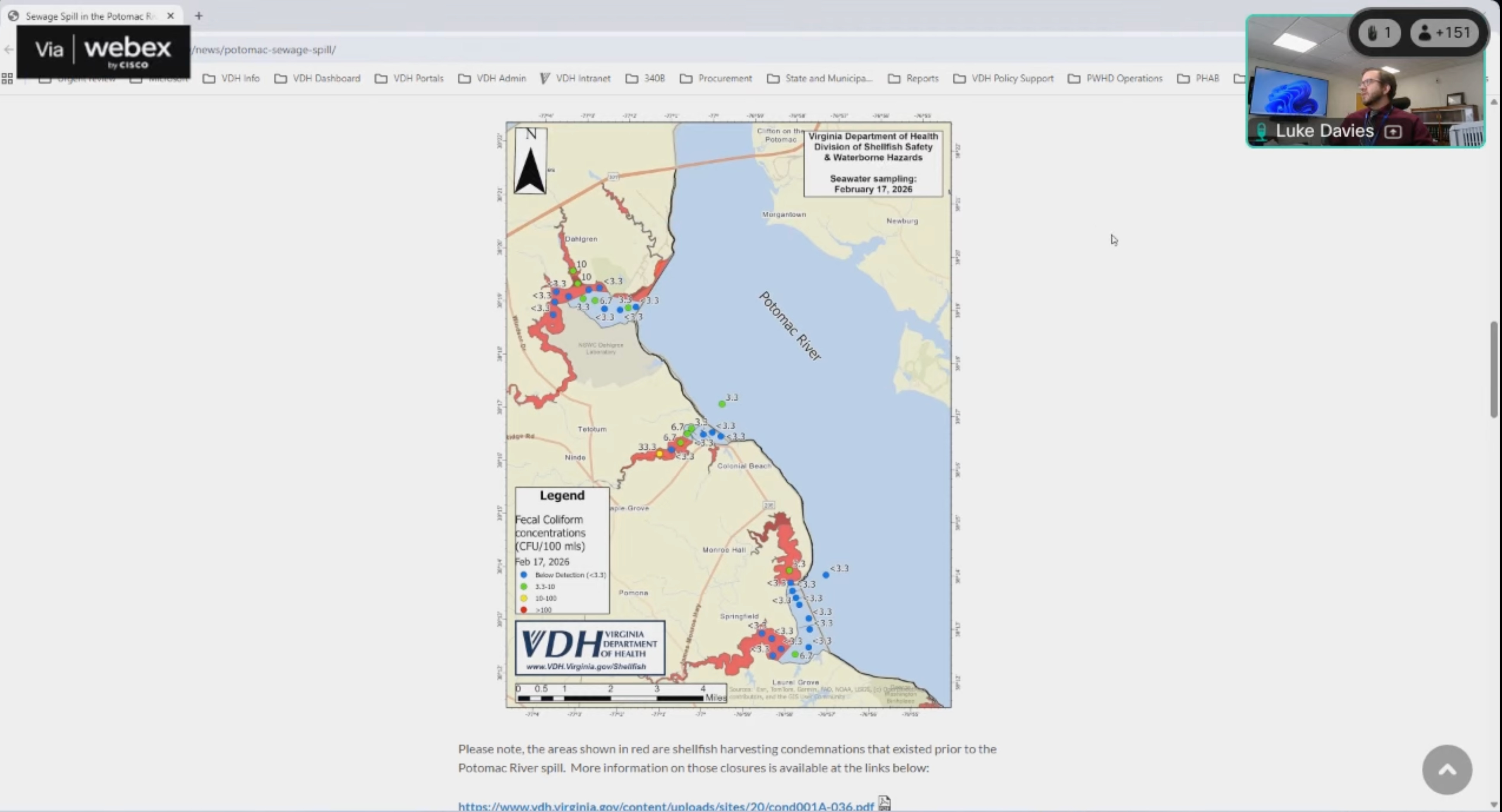
VDH’s Division of Shellfish Safety sampled 36 sites from Colonial Beach to the Route 301 Bridge on February 17 and found no elevated fecal coliform concentrations. The vast majority of results were at or below the detection limit. Virginia shellfish growing areas are not currently impacted by the spill. The red-shaded areas on VDH’s shellfish maps represent pre-existing condemnations in Upper Machodoc Creek, Rosier Creek, and Monroe Bay that predate the collapse.
Maryland’s shellfish closure — issued January 25 and covering waters from the spill location to the Nice Bridge — remains in effect on the Maryland side.
How fast contamination travels
ICPRB scientist Dr. Cherie Schultz presented modeling Monday showing that in the event of a release from the spill site, peak pathogen levels flow past DC’s southern border — which adjoins Alexandria — in less than one day under typical February river conditions. The model does not account for tidal currents or sediment deposition, which could extend contamination beyond what the model predicts. Schultz also flagged longer-term risks: sewage nutrients may fuel harmful algal blooms this summer, and sewage sludge on the riverbed could elevate the risk of fish kills in coming months.
Two public meetings this week — neither in Virginia
DC Water announced two community briefings: Wednesday, February 25, at 7 p.m. at DC Water headquarters and Thursday, February 26, at Walt Whitman High School in Bethesda. Both will be live-streamed. No Virginia public meeting was announced. COG Executive Director Clark Mercer acknowledged a question about it on the call but made no commitment.
Additional Virginia DEQ sampling is planned in the coming weeks. DC’s DOEE plans to move to daily sampling beginning the week of March 2. We will report new Virginia results as they are published.
What to do
Avoid physical contact with the Potomac River. Keep pets out of the water. If contact occurs, wash immediately with soap and water. If you develop gastrointestinal symptoms, rashes, or ear, nose, or throat infections after river exposure, contact a healthcare provider and mention the exposure. More at SwimHealthyVA.com.