

Table of Contents
ALEXANDRIA, Va. — Alexandria remains under a state drought warning, but for the first time since April a part of Virginia is out of the drought entirely.
The Virginia Drought Monitoring Task Force lifted the drought watch covering the Big Sandy region in far southwestern Virginia on Thursday, citing several weeks of sustained rain. It is the first evaluation region in the state to return to normal status since April 16. The region takes in Buchanan, Dickenson, Lee, Russell, Scott, Smyth, Tazewell, Washington and Wise counties and the cities of Bristol and Norton.
Every other advisory in the state was continued, as they were in the task force's last update a week ago. Northern Virginia — Arlington, Fairfax, Fauquier, Loudoun and Prince William counties and the cities of Alexandria, Fairfax, Falls Church, Manassas and Manassas Park — stays in warning status, the third of the state's four drought classifications. Alexandria has been under a warning since the state expanded it statewide in April.
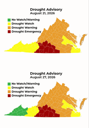
The Roanoke River region remains under a drought emergency, the most serious of the four. The task force said that region has received less rain than the rest of the commonwealth — about 57% of normal for this point in the year, according to DEQ.
Statewide, rainfall is running roughly 7.8 inches below normal, which the agency describes as the second-driest water year on record. DEQ says current conditions resemble the drought that hit Virginia in 2002.
Above ground is recovering. Below ground is not.
The split that has defined this drought held again.
Streamflows were largely normal, with much-below-normal flows confined to parts of the Roanoke and Upper James basins and tributaries of the Shenandoah River. Soil moisture is near normal in most of the state, the exception being a dry corridor running from Staunton through Lynchburg and east toward Emporia.
Groundwater moved in both directions at once. Areas already above normal rose further; areas below normal fell further. Wells in southern Prince William County, along with Patrick and Rockbridge counties, are at or near record lows.
Aquifers recharge over months and seasons rather than storms, which is why a wet stretch can restore streams and topsoil while wells stay near record lows.
Reservoirs statewide are within normal ranges except Smith Mountain Lake and the John Kerr Reservoir, both far below normal for late August.
Rainfall over the past week was above normal across much of Virginia, with localized storms dropping 3 to 5 inches in parts of the Big Sandy region and in Accomack, Orange and Westmoreland counties. Over the past 30 days, though, a swath from Staunton through Lynchburg to Danville and east across southeast Virginia has received only half to three-quarters of normal precipitation.
What it means here
The guidance for Alexandria residents remains conservation rather than restriction. Gov. Abigail Spanberger is encouraging Virginians to conserve water, and the state recommends limiting nonessential use — watering lawns on alternating days and only between dusk and dawn, shutting off ornamental fountains, cutting back on car and driveway washing, and holding off on filling pools.
Virginia American Water, which serves the city, asked residential customers in July to voluntarily reduce nonessential use, a request that applies to households rather than businesses or industrial customers.
Alexandria draws its drinking water from the Potomac River, and the city is covered by a regional drought watch declared in June by the Metropolitan Washington Council of Governments spanning nearly six million people across the District, suburban Maryland and Northern Virginia.
The seven-day forecast the state cited offers northern Virginia the least. It calls for a quarter to half an inch of rain in northern and southwestern Virginia, below normal for the period, with the heavier totals of three-quarters of an inch to an inch and a quarter falling in the southeast.
Locally, the National Weather Service gives Alexandria a slight chance of showers and thunderstorms Friday afternoon and again late Monday night, with no measurable rain in the forecast otherwise. Highs reach the upper 80s Friday, drop to about 85 Saturday, then climb through the week — near 89 Sunday, 93 Monday, 94 Tuesday and 95 Wednesday. Chances of showers and storms return Wednesday and hold through Thursday, with overnight lows in the mid-70s by midweek.
The task force, which has been meeting weekly, next convenes Sept. 1.
Current conditions are available on DEQ's drought webpage and its Drought Dashboard, which tracks stream gauges, groundwater wells, soil moisture and precipitation.
Ryan Belmore is an Alexandria resident and the founder and publisher of The Alexandria Brief. Send tips, feedback, and story ideas to ryan@alexandriabrief.com.