Table of Contents
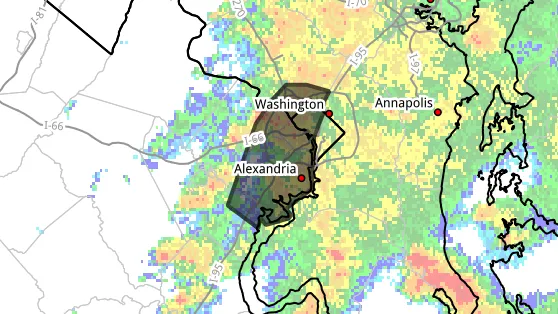
ALEXANDRIA, Va. — The National Weather Service has issued a flash flood warning covering Alexandria and much of the surrounding region until 7:45 p.m. Sunday, with forecasters warning that flooding is either already underway or expected to begin shortly.
Between 1.5 and 3 inches of rain had fallen across the warned area as of 4:34 p.m., according to the warning issued from the Weather Service's Sterling office. Another 1 to 2.5 inches is possible.
The warning also covers Arlington County, eastern Fairfax County, eastern Prince William County, Falls Church, the southeastern portion of the City of Fairfax, northwestern Washington, D.C., and southeastern Montgomery County. Forecasters specifically named Alexandria, along with Groveton, Huntington, Fort Hunt and Crystal City, among locations expected to see flash flooding.
Forecasters warned of flooding on small creeks and streams, in urban areas, and on highways, streets and underpasses, as well as in low-lying and poor-drainage areas.
The Weather Service's guidance is direct: turn around, don't drown. Most flood deaths happen in vehicles. Officials also urged residents to keep children away from storm drains, culverts, creeks and streams, where water levels can rise fast enough to sweep a child away.
A flood watch through midnight
Beyond the warning, a broader flood watch remains in effect for Alexandria, Arlington, Falls Church, Fairfax and parts of Maryland and D.C. until midnight.
Parts of the Washington region had already picked up 1 to 2 inches of rain earlier Sunday before the afternoon storms, forecasters said. They cautioned that additional waves of showers and thunderstorms could train over the same areas through the evening, adding another 1 to 2 inches and potentially more.
What's ahead
Showers and thunderstorms are expected to continue overnight, tapering to a chance of showers before dawn. The overnight low is around 73.
Monday brings another round: a chance of storms in the morning, showers likely and possibly a thunderstorm in the late afternoon, and a high near 87. Rain chances drop to 30% Monday night.
Tuesday looks mostly cloudy and dry, with a high near 86.
Looking further out, the Weather Service's hazardous weather outlook flags scattered thunderstorms Thursday through Saturday, mainly in the afternoon and evening, with damaging wind gusts and isolated flash flooding possible.
Boaters should note a separate special marine warning was in effect on the tidal Potomac Sunday afternoon for wind gusts of 34 knots or greater.
This story will be updated.