Table of Contents
ALEXANDRIA, Va. — On June 16, 1809, a petition was filed with the Virginia General Assembly to construct a new turnpike linking Alexandria with Fredericksburg, roughly 50 miles to the south. Construction began soon after on a causeway across the Great Hunting Creek and a road that pushed through what was then the rural wilderness of eastern Fairfax County, passing the Huntley meadows, Mount Vernon, Woodlawn and the town of Woodbridge.
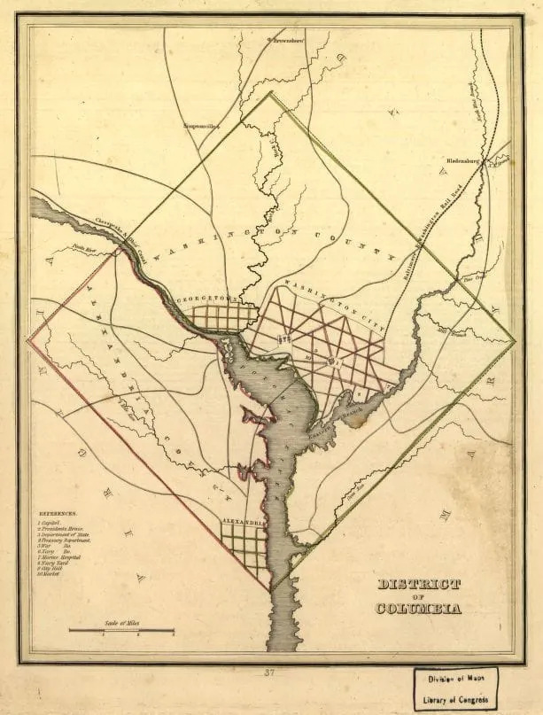
The same year, a second new turnpike was built north of Alexandria. That road, running roughly along what is now Powhatan Street, extended from the northern dead-end of Washington Street to connect with the Long Bridge across the Potomac River, finally providing a direct road link between Alexandria and Washington Counties — the two original counties that made up the District of Columbia.
Together, the two roads transformed Alexandria's place in the region's transportation network.
Alexandria as a port and a place in transition
In 1809, Alexandria was a busy commercial port — the largest town in what was then the District of Columbia, of which it had been part since 1791. Tobacco warehouses, flour mills, ship chandlers and rope makers lined the waterfront, and the city's merchants moved goods to ports up and down the Atlantic coast. But Alexandria's connection to the agricultural interior of Virginia was poor, and the routes connecting Alexandria to its neighbors — Washington City (today's Washington, D.C.) to the north, Fredericksburg to the south, and the Shenandoah Valley to the west — were rough, slow and often nearly impassable in winter.
The turnpike era was the early-19th-century answer to that problem. Turnpikes were private toll roads, chartered by the state and built with private capital, that promised reliable, all-weather routes in exchange for the right to charge users a toll. The first successful turnpike in the South had been the Little River Turnpike, chartered in 1795 to extend west from Alexandria along what is today Duke Street, and finally completed in 1811 as a 34-mile improved road reaching the Blue Ridge foothills at Aldie. Other charters followed quickly — the Leesburg Turnpike that same year of 1809, the Snicker's Gap Turnpike in 1810.
The Alexandria-to-Fredericksburg route was different in character. It ran south through the lowland tobacco and grain country between Alexandria and Fredericksburg, on land that had been farmed but not heavily settled, and it would eventually parallel the path of generations of north-south travel from New England to the Carolinas.
From Hunting Creek to U.S. Route 1
The road that grew out of the 1809 petition would, in time, become part of one of the original federal highways established in 1926. U.S. Route 1, designated in that first numbering of national highways, follows the East Coast from Fort Kent, Maine, near the Canadian border, to Key West, Florida — a distance of roughly 2,400 miles. The Alexandria-to-Fredericksburg segment that began with the 1809 petition is now Richmond Highway through Alexandria and Fairfax County, then Jefferson Davis Highway and Patrick Henry Highway through more southern Virginia counties before it reaches Fredericksburg and points south.
That same stretch of road — the part that runs through Alexandria's south end and on toward Mount Vernon — would later carry traffic to Fort Belvoir during World War I, when the U.S. Army paved a portion to accommodate heavy military traffic to Camp A.A. Humphreys, as Fort Belvoir was then known. Other segments were paved and widened in the 20th century, and the road eventually carried U.S. 1 traffic for nearly a century before Interstate 95 was built parallel to it in the 1960s and 1970s.
Two roads, one shift
What the 1809 turnpike petitions reflect — both the Fredericksburg road south and the Long Bridge connection north — was a city beginning to organize itself around a question that would shape Alexandria's next 50 years: how to remain commercially relevant as the District of Columbia capital matured to the north, as Baltimore competed for trade, and as the wheat and tobacco lands of the Virginia interior were drawn into the federal economy.
Alexandria would not get every answer right. The city's economic prominence relative to its neighbors would decline through the early 19th century. But the road network the city helped build in the 1800s and 1810s, much of it still in use today, connected Alexandria to the country in ways its founders in 1749 could not have imagined.
Information via the City of Alexandria's Office of Historic Alexandria, the Virginia Department of Historic Resources, the Virginia Library, the Library of Virginia legislative petitions archive, and the Northern Virginia History Notes archive.


