Table of Contents
This story was originally published at 4:03 p.m.
Update at 5:38 p.m.
The National Weather Service cancelled Severe Thunderstorm Watch 555 for Alexandria at 5:35 p.m., more than three hours before its scheduled 9 p.m. expiration. Both severe thunderstorm warnings issued for the city Monday afternoon have expired.
Update at 5:32 p.m.
Dominion Energy reported 15 customers without power on Stonebridge Road as of 5:32 p.m., the only outage listed in Alexandria on the utility's map. The cause and estimated restoration time were both pending investigation, and a crew had not yet been assigned.
Update at 5:22 p.m.
The National Weather Service upgraded its special marine warning for the tidal Potomac at 5:14 p.m., citing observed wind gusts in excess of 48 knots — about 55 mph — along with small hail. The warning runs until 5:45 p.m. and covers the river from Key Bridge to Indian Head, Md., including Alexandria, the Woodrow Wilson Bridge, National Harbor and Reagan National Airport.
Forecasters told boaters to move to safe harbor immediately, warning that people could easily be thrown overboard and that vessels could capsize or suffer significant damage. Earlier in the afternoon, the same warning cited radar-indicated gusts of 34 knots; the 5:14 p.m. update is based on measured wind.
On land, a severe thunderstorm warning issued at 5:05 p.m. for Alexandria expires at 5:30 p.m. Forecasters said a severe thunderstorm was sitting over the city at 5:05 p.m., moving east at 25 mph, with 60 mph gusts possible.
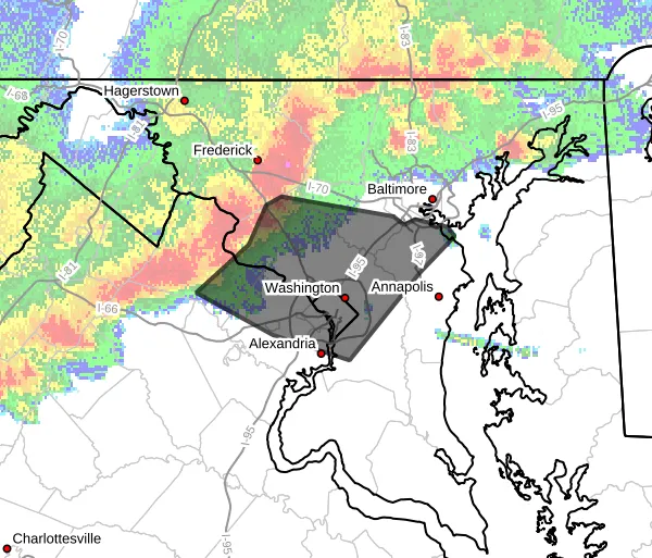
Severe Thunderstorm Watch 555 remains in effect until 9 p.m., though its footprint has contracted sharply — from 12 Maryland counties and 30 Virginia localities earlier in the afternoon to five and 11 now, as the threat consolidates over the immediate Washington area and points south. Alexandria remains included.
Original Story
Published at 4:03 p.m.
ALEXANDRIA, Va. — The National Weather Service has issued a severe thunderstorm warning for Alexandria until 4:45 p.m. Monday.
Forecasters said at 3:57 p.m. that severe thunderstorms with a history of producing wind damage were moving east at 40 mph along a line from Damascus to near Boyds to Broadlands. The main hazard is 60 mph wind gusts, which the weather service listed as observed rather than only radar-indicated.
Damaging winds can bring down trees and large branches, injuring people outdoors and damaging homes and vehicles. Roadways may become blocked and localized power outages are possible. Unsecured light objects may become projectiles.
The weather service advises moving to an interior room on the lowest floor of a building. It warned of continuous cloud-to-ground lightning, noting that anyone who can hear thunder is close enough to be struck. Torrential rain accompanies the storms and may cause flash flooding; do not drive through flooded roadways.
The warning also covers Arlington, Fairfax County, Falls Church, the City of Fairfax, southeastern Loudoun County and the District, along with several Maryland counties.
More storms possible into the evening
The warning falls within Severe Thunderstorm Watch 555, which runs until 9 p.m. across the region and covers the District, 12 Maryland counties and 30 Virginia localities. Forecasters said scattered severe thunderstorms are possible through the evening, with damaging wind gusts the primary hazard, and that additional severe storms capable of producing damaging winds are possible again Tuesday. The Skywarn spotter network has been activated.
On the water
A separate special marine warning covers the tidal Potomac from Key Bridge to Indian Head, Md., until 5:45 p.m. Forecasters warned of gusts of 34 knots or greater, which could throw boaters in small craft overboard or capsize a vessel. Locations named include Alexandria, the Woodrow Wilson Bridge, National Harbor and Reagan National Airport.
The rest of the week
Today's high reached near 95 with a 70% chance of precipitation, and showers and thunderstorms remain likely through 11 p.m., some possibly severe, before tapering to a slight chance of showers around midnight. The overnight low is near 75.
Tuesday brings a repeat, though a lesser one: partly sunny, high near 91, with a 40% chance of showers and thunderstorms mainly after 3 p.m., rising to 60% Tuesday night before 11 p.m.
Conditions ease midweek. Wednesday is partly sunny and cooler at 88 with a 20% chance of storms; Thursday mostly sunny near 90, also 20%. Friday tops out near 86 with a 30% chance of afternoon storms and an overnight low around 68 — the most comfortable night of the week.