ALEXANDRIA, Va. — People filed 241 reports of near misses and dangerous locations in Alexandria over an 18-month stretch, and children were present or nearby in more than half of them, according to a report released this month by Northern Virginia Families for Safe Streets.
The group is a 501(c)(3) nonprofit based in Alexandria with chapters here, in Arlington and in Fairfax. It collects the reports through a survey open to anyone walking or biking who has a close call or wants to flag a location, and publishes the results on a public dashboard. The Alexandria data covers Jan. 1, 2025, through June 30, 2026, and is part of a regional report spanning 506 reports across the three jurisdictions. Alexandria, the smallest of the three, accounted for nearly half of them.
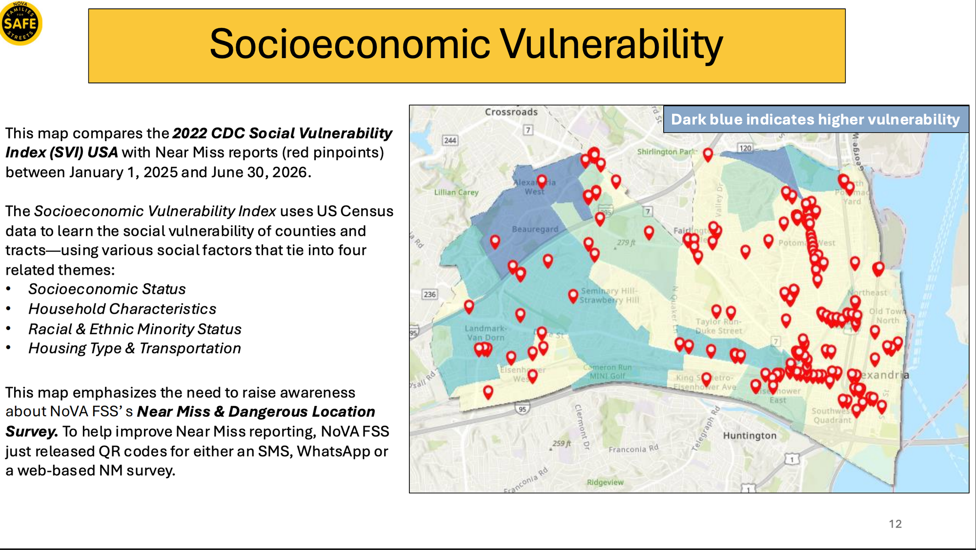
The reports are self-selected, not a random sample. The group acknowledges one limit of that: its own mapping against the CDC's Social Vulnerability Index suggests reporting is uneven across neighborhoods and that risk may be underrepresented in more vulnerable areas.
What the reports say
Failure to yield was cited in 76% of Alexandria reports. Speeding appeared in 36% and failure to obey a traffic signal or sign in 35%.
Reports clustered during commute hours, 6 to 9 a.m. and 3 to 6 p.m., and peaked on Thursdays, which accounted for 20% of the total. April 2026 was the heaviest month with 34 reports.
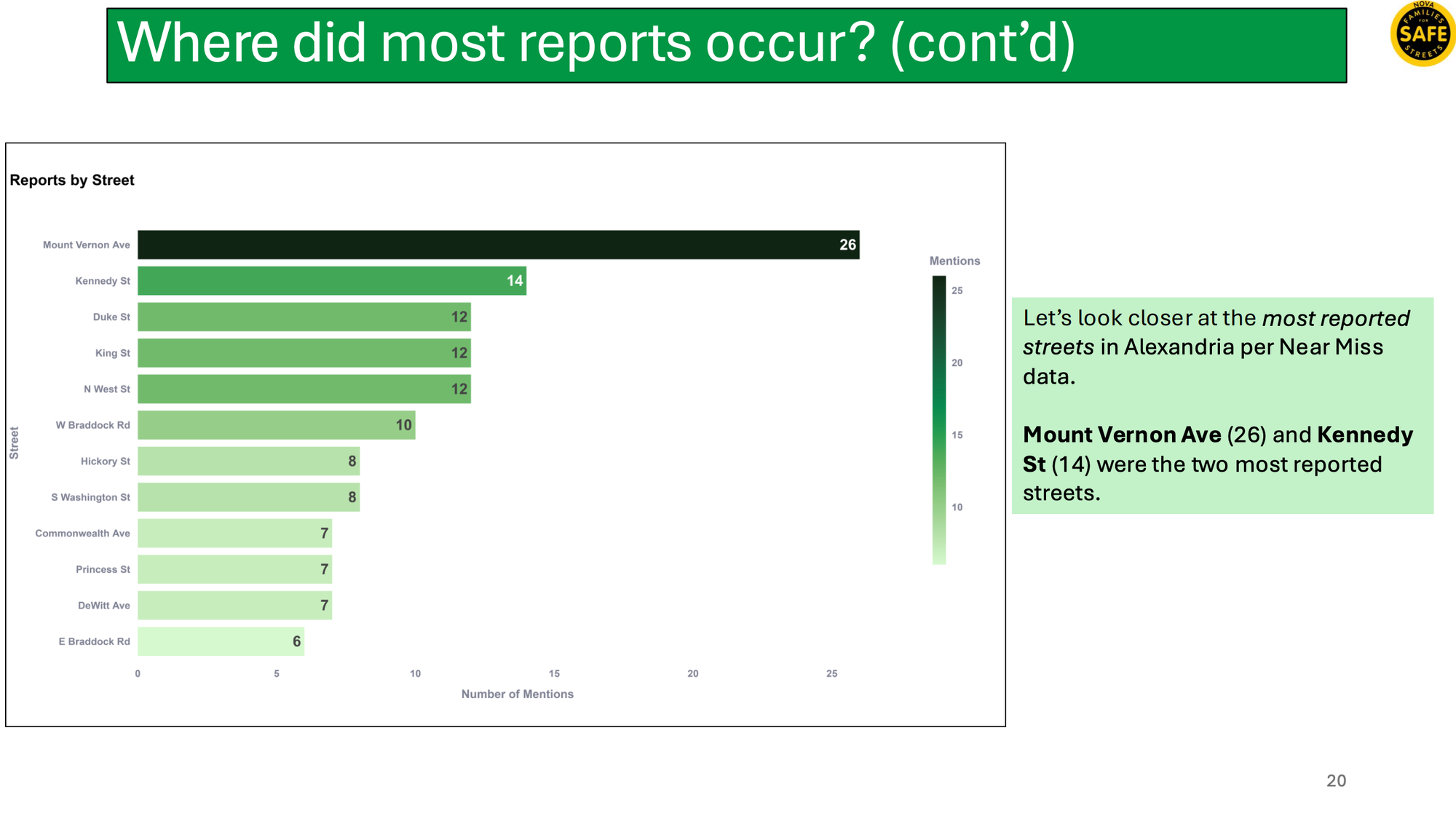
Potomac West, the area commonly known as Del Ray, drew the most reports of any part of the city with 45. Mount Vernon Avenue was the most reported street with 26, followed by Kennedy Street with 14. The Braddock Road Metro area and Old Town also appeared frequently.
For pedestrians, the streets cited most often were Mount Vernon Avenue, Kennedy Street, North West Street, Duke Street and King Street. For cyclists, King Street, Kennedy Street and Duke Street.
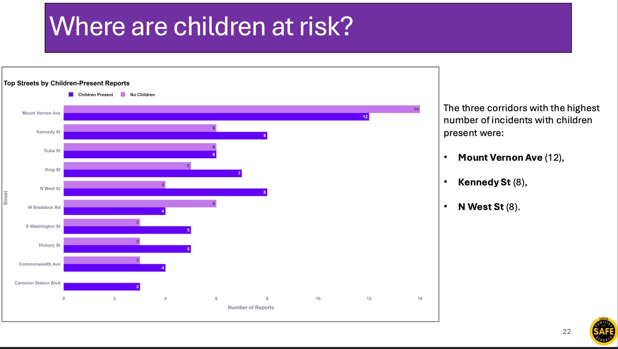
Children were present or nearby in 124 reports, or 52%. Failure to yield appeared in more than 77% of those. The corridors with the most reports involving children were Mount Vernon Avenue with 12, and Kennedy Street and North West Street with eight each.
Nine locations
The report builds case studies around nine locations, drawing on resident testimony and, in one case, hard-braking data from vehicle telematics.
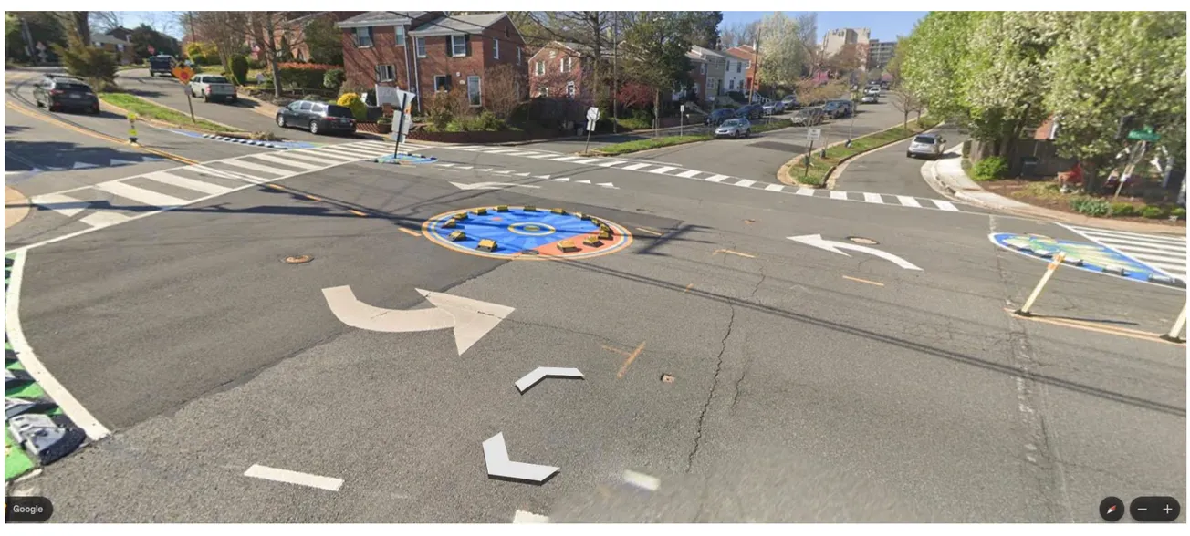
- Kennedy Street and Hickory Street, where residents describe a mini-roundabout drivers fail to recognize and crosswalk islands that leave pedestrians stranded between lanes.
- South Washington Street and Wilkes Street, near Lyles-Crouch Traditional Academy, where a pedestrian was killed in 2020.
- Mount Vernon Avenue, at East Del Ray, East Custis and East Oxford avenues, a corridor the report says is lined with seven schools and child care centers.
- Duke Street and West Taylor Run Parkway, red-light running through crosswalks.
- Cameron Station Boulevard, speeding near Samuel W. Tucker Elementary School.
- North Hampton Drive at West Braddock Road, speeding on a grade near a major bus stop.
- North Beauregard Street and King Street, at the Arlington line, where one cyclist reported being hit by a turning DASH bus and others described drivers turning across crosswalks.
- Radford Street and West Braddock Road, an unsignalized crossing to housing and schools.
- Kenwood Avenue and West Braddock Road, red-light running with narrow sidewalks and no bike lane.
At Kennedy and Hickory, one resident wrote in February that children walking to Mount Vernon Community School with adults were caught on a painted island while cars passed on both sides. "No one was hit but the pedestrians were stuck on an 'island' for several minutes while cars (speed) past inches away on either side," the report quotes the resident as writing.
Another, from April, described being stranded on the same island as four vehicles crossed the intersection, one of them entering the island area.
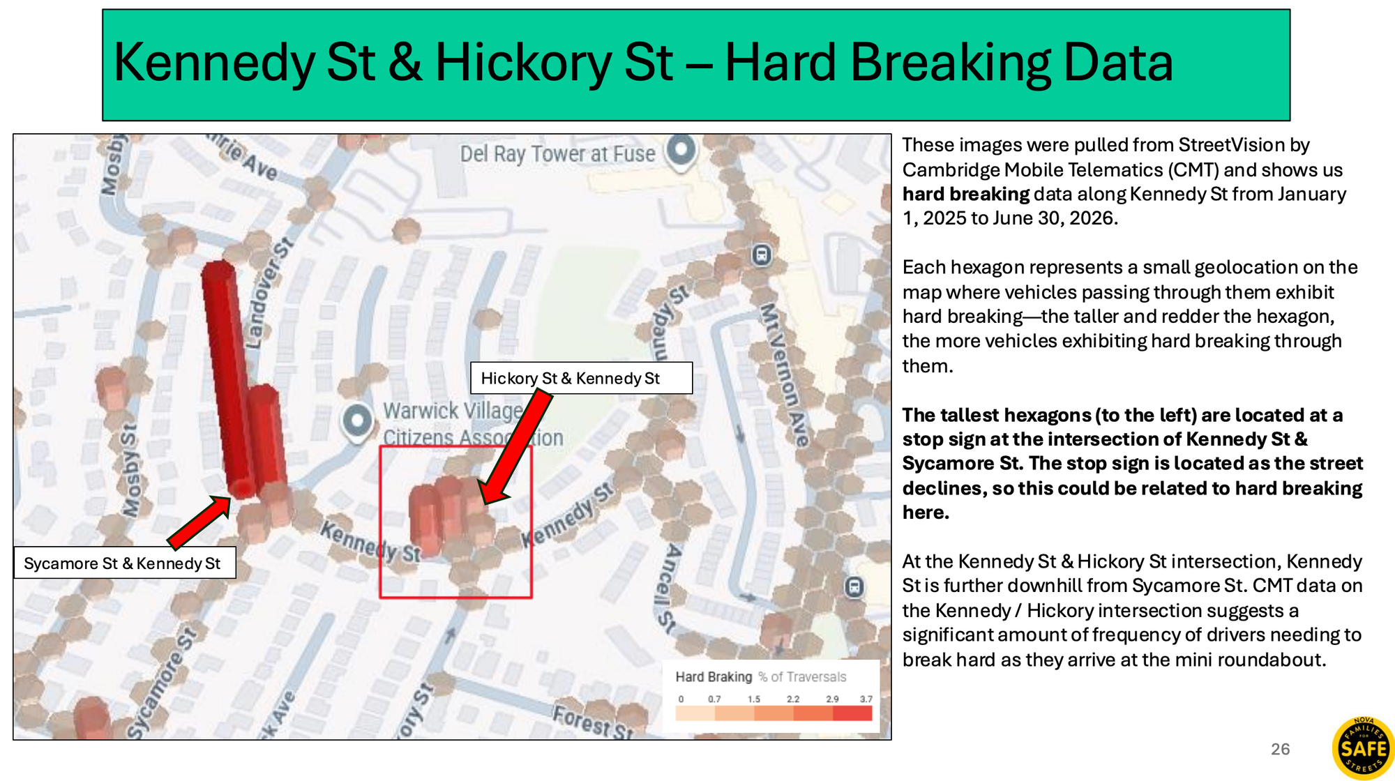
The group pulled hard-braking data for Kennedy Street from StreetVision by Cambridge Mobile Telematics. The heaviest hard braking on the map is at a stop sign at Sycamore Street, where the street slopes downhill. The report says the data also suggests drivers frequently brake hard as they reach the mini-roundabout at Hickory, farther down the hill.
At South Washington and Wilkes, the report notes the death of Justin Benedict, 55, who was struck by an SUV driver while crossing on Nov. 20, 2020, and died days later.
The city's own program
Alexandria adopted Vision Zero in December 2017, committing to eliminate traffic deaths and severe injuries by 2028. The city says more than 150 people were killed or severely injured in crashes here between 2017 and 2021, and that 70% of fatal or severe crashes from 2016 to 2020 happened on about 10% of the street network. The city ended 2023 with no traffic fatalities.
Several of the corridors in the near-miss report already appear in the city's work. Mount Vernon Avenue North and Braddock Road are among current Vision Zero projects, along with speed cameras in school zones, leading pedestrian intervals and no-turn-on-red restrictions, and corridor speed management. The city also maintains a public crash dashboard and a high-injury network map.
The near-miss data is different in kind. The city's crash dashboard covers crashes reported to police that involved an injury, a death or at least $1,500 in damage.
That dashboard, which draws on Virginia Department of Transportation data, currently runs through March 31, so it overlaps with the first 15 months of the near-miss report. Over that span, it shows 812 crashes on city-maintained streets: 653 in 2025 and 159 in the first three months of 2026. Those figures include crashes of every type, not only those involving people walking or biking, and leave out roads maintained by the state and other agencies.
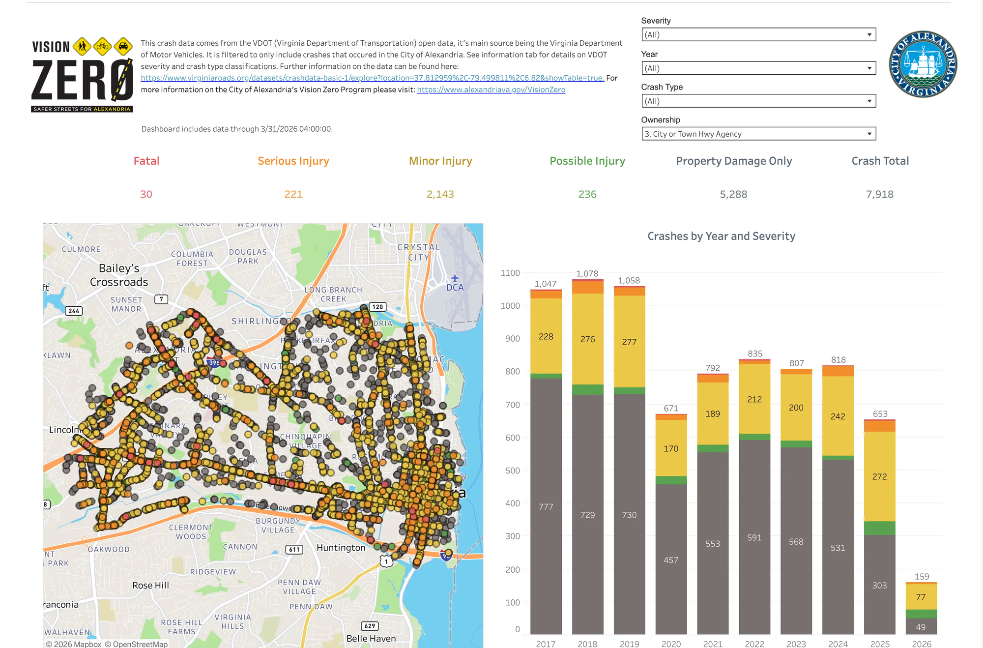
The 2025 total is the lowest of any year the dashboard shows, going back to 2017, and below the 671 crashes recorded in 2020, the first year of the pandemic. The city recorded more than 1,000 crashes a year from 2017 through 2019. Since 2017, the dashboard lists 30 fatal crashes and 221 crashes with serious injuries on city-maintained streets.
A driver who runs a stop sign and misses a child in a crosswalk generates no crash report and appears in none of those numbers.
The Brief has asked the city whether it tracks near misses in any form, and whether it has reviewed the report.
Daylighting and Russell Road
The group has used near-miss data to argue for specific projects, among them daylighting, the practice of keeping cars out of the spaces closest to a corner so drivers and pedestrians can see each other. The most contested recent example in Alexandria is Russell Road near Naomi Brooks Elementary School.
That project has taken a complicated path. The Traffic and Parking Board voted 5-2 in July to remove 20 on-street spaces, going well beyond a staff recommendation that would have produced a net loss of two. On Aug. 7, T&ES Director Leah Riley told the board the city would not implement its recommendation and selected a different plan, Alternative C, which removes 12.5 spaces and adds parking elsewhere. The board's vote never took effect, and the city later corrected the parking figures it had published for the alternative.
Russell Road is not among the nine locations in the near-miss report. The construction there is expected in 2027, when the city repaves the road.
What the group recommends
The report makes seven recommendations. The first is to carry out the fixes proposed in its case studies, including stop signs and speed bumps at Kennedy and Hickory, turn wedges at South Washington and Wilkes, and enforced-crosswalk signage along Mount Vernon Avenue.
Others call for automated enforcement, signage and police campaigns aimed at failure to yield on the most-reported corridors; more speed enforcement and traffic calming near schools during arrival and dismissal; and stop-sign cameras around selected school zones, more speed cameras, and temporary traffic controls from 6 to 9 a.m., from 3 to 6 p.m. and on Thursdays.
Alexandria already runs speed cameras in several school zones during arrival and dismissal. It does not use stop-sign cameras.
The report also recommends promoting the group's new QR-code survey in higher-vulnerability neighborhoods to close the reporting gap, continuing to pair testimony with telematics and crash data, and tracking corridors under construction, such as East Braddock Road, to see whether the work reduces reports.
A separate camera debate
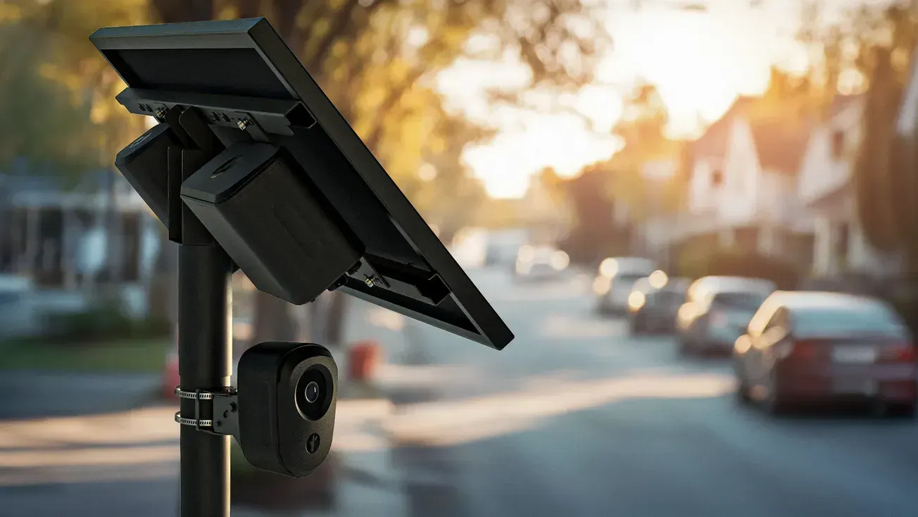
The recommendations arrive as City Council weighs removing a different camera system. Mayor Alyia Gaskins told council last week she does not think there is a role for Flock license plate readers in Alexandria, and the Alexandria Times has reported that all seven council members support taking them out. Eleven agencies holding federal immigration task force agreements came off the city's Flock sharing list over the weekend.
The two systems work differently. License plate readers scan and store the plates of passing vehicles, and other agencies can search that data. Traffic enforcement cameras photograph a specific violation, such as speeding in a school zone, and generate a ticket. The near-miss report does not mention license plate readers.
The survey and the dashboard are at novasafestreets.org and below.
Ryan Belmore is an Alexandria resident and the founder and publisher of The Alexandria Brief. Send tips, feedback, and story ideas to ryan@alexandriabrief.com.
© 2026 Alexandria News, LLC. All rights reserved. This material may not be published, broadcast, rewritten or redistributed without permission.