Editor's note: On Friday, Aug. 14, the city announced that it has extended the public comment period through Sept. 15. Read the latest here.
Updated Aug. 7, 9:35 a.m.: This story has been updated to include the plan glossary's condition that Option B for Luckett Field applies only if another location for the field is secured.
ALEXANDRIA, Va. — Residents have until Friday, Aug. 21, to comment on the 25 draft recommendations that would guide development along Duke Street for the next two decades, a set of proposals city planners said Wednesday they are still willing to change.
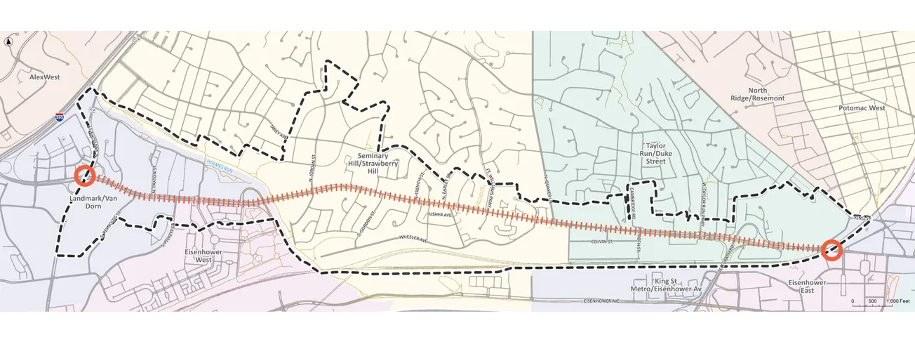
The recommendations, posted July 20, cover roughly seven miles from Alexandria Union Station to Van Dorn Street and represent the first comprehensive rethinking of the corridor's land use since 1992. They address building heights and length, affordable housing requirements, retail, parking, street design, parks and tree canopy. The city has also posted a set of accompanying figures and a glossary of terms for readers working through the document.
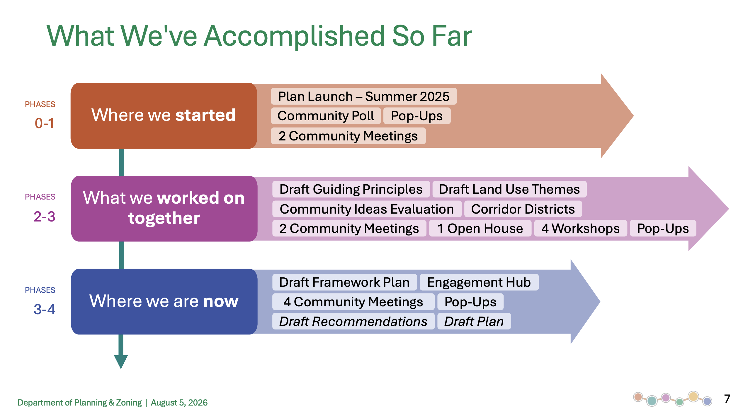
At Wednesday's virtual meeting — the eighth since the process began in June 2025 — Deputy Director Jeff Farner of the Department of Planning and Zoning said the format was deliberate. Earlier city plans ran long and dense, he said; residents asked for fewer recommendations, plainer language and graphics that made the intent clear.
The Alexandria Brief previewed the recommendations ahead of the meeting.
What staff agreed to reconsider
Several questions drew commitments to take another look.
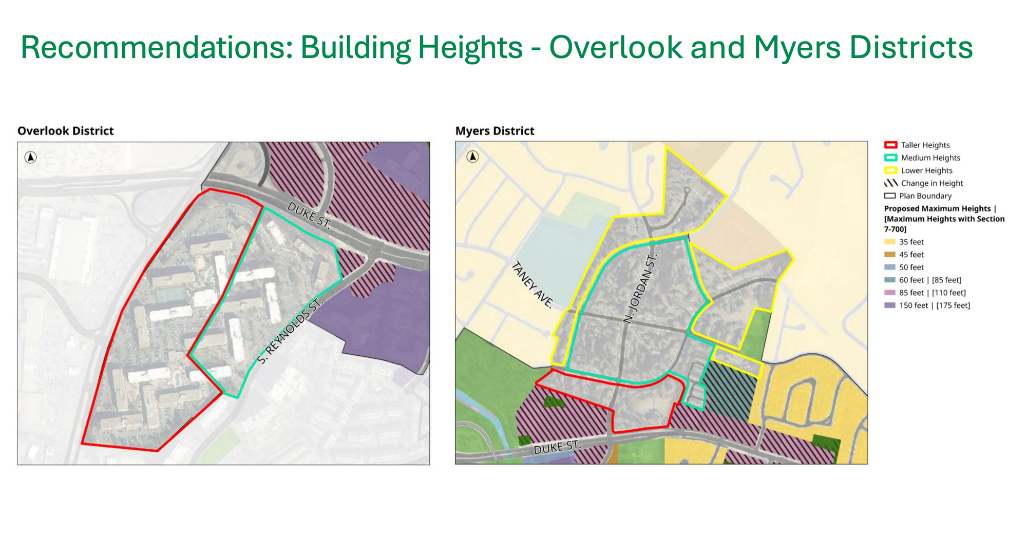
Asked why the Mason at Van Dorn site proposes taller buildings along Van Dorn Street but medium heights along Reynolds Street, where high-rises already stand, Farner called it a fair question and said staff would examine it. "That's exactly the reason we share things in drafts," he said.
He also agreed to study whether the 13-foot sidewalks on retail streets could be redesignated as multi-use paths, after two residents noted the commercial cross-section includes no lanes where e-bikes and scooters could legally travel. A related question about King Street — which one resident called uncomfortable to bike along — arose because Farner had used King Street as an example of a slow-moving retail street, not because the plan proposes changes there.
Height ranges for Mason at Van Dorn and Foxchase, the corridor's two largest housing complexes, have not been set. Farner said the concept is lower buildings at the perimeter next to existing neighborhoods, stepping up toward the middle and toward Duke and Van Dorn streets.
Affordable housing
One resident asked why the city isn't requiring more than 10 percent affordable units, noting Fairfax County has required 12 percent for a decade.
Farner restated the recommendation without addressing the comparison: development that exceeds base residential zoning must provide 10 percent of the additional density as on-site committed affordable units at 60 percent of area median income, or whatever city policy requires at the time — whichever is greater.
Urban Planner Melissa Sims said the housing recommendations aim both to preserve existing units and create new ones across price levels. Duke Street holds one of the city's largest supplies of market-rate affordable housing, Farner said, and density is among the few tools available to retain it.
Asked whether the city encourages mixed-income development along the lines of Montgomery County, Maryland, Farner pointed to Housing 2040, the recent housing master plan, and said the emphasis is on keeping every tool available — density, height and partnerships with nonprofits — rather than relying on one.
The traffic question
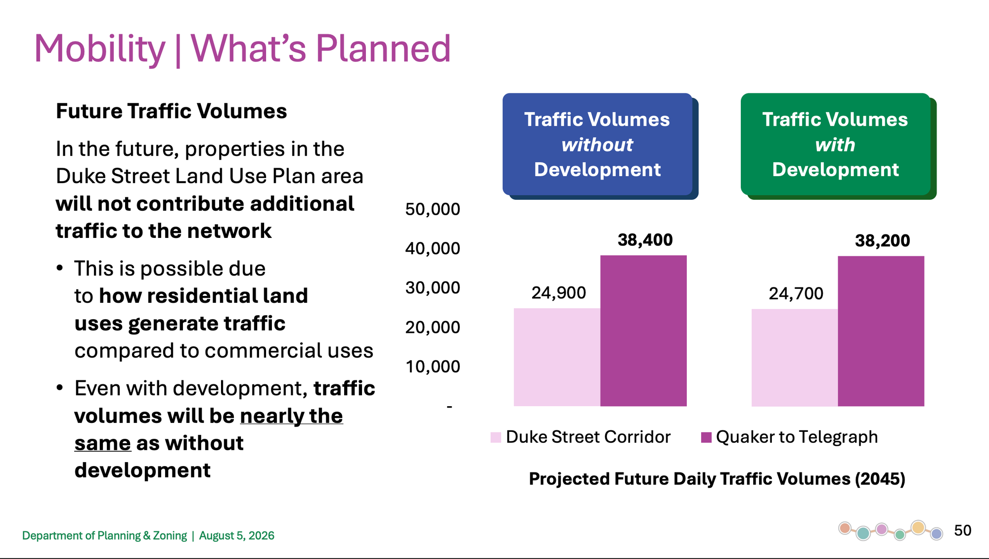
The presentation's most contested claim is that adding housing won't add traffic.
City projections put 2045 daily volumes on the Duke Street corridor at 24,900 vehicles without the plan's development and 24,700 with it. From Quaker Lane to Telegraph Road, the figures are 38,400 and 38,200. Staff attribute the near-identical numbers to residential uses generating fewer trips than the commercial uses they would replace.
Farner offered a fuller explanation when a resident argued that gridlock between Quaker Lane and Telegraph Road must be solved before redevelopment can happen. Much of that congestion, he said, is regional traffic cutting between Interstates 495 and 395 by way of Seminary Road, Quaker Lane and Telegraph Road. As local trips increase, he said, regional drivers are expected to return to the interstates — leaving a similar vehicle count with a different composition.
Congestion on the corridor's eastern end has come up before in the process. Councilman John Chapman raised it in February, noting commercial rents there are among the lowest in the city partly because drivers pass through without stopping.
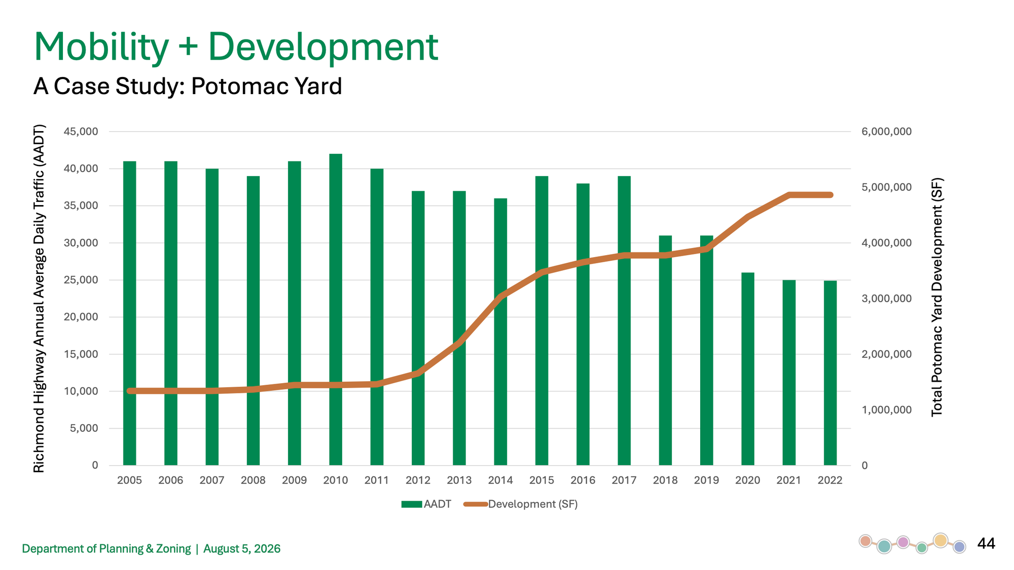
The deck's supporting evidence is Potomac Yard, where traffic on Richmond Highway fell from about 41,000 vehicles a day in 2005 to roughly 25,000 in 2022 as development there approached 5 million square feet.
Farner deferred detailed questions to Transportation and Environmental Services, which is designing the Duke Street Transitway approved by City Council. Bike facilities will be protected where right-of-way allows, he said, though they may not be continuous at first.
Parks, trees and open space
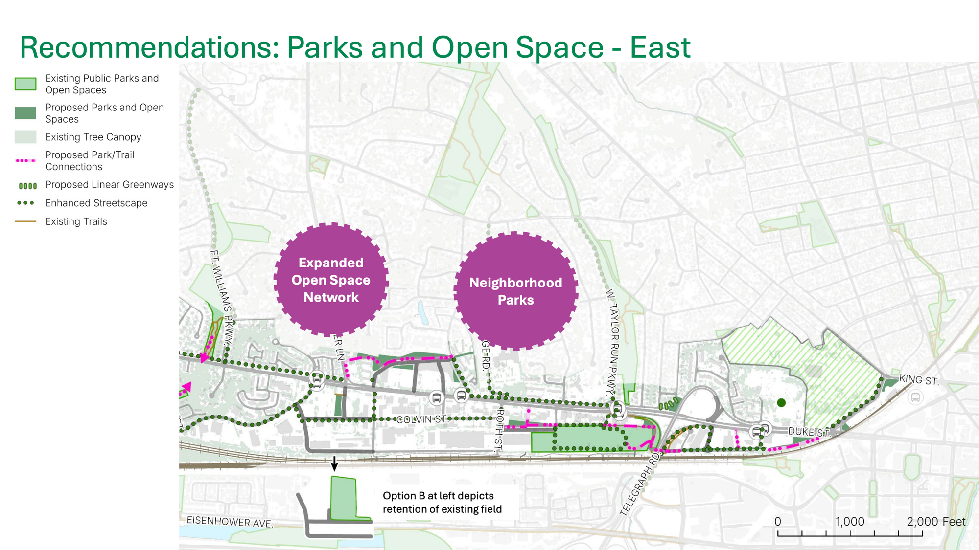
Farner said the corridor has several large parks but few neighborhood ones. The plan proposes new parks tied to redevelopment, with designs to be worked out through separate community processes as projects come forward.
Among the connections: a new open space where the postal facility sits today, and a greenway running under the Telegraph Road bridge to link Witter Field with the King Street Metro station. A resident had described the existing underpass as scary.
Two options remain on the table for Luckett Field, though the plan sets a condition. The glossary accompanying the recommendations calls the field a highly utilized recreation resource that should be retained either in place or elsewhere in the city; Option B, which would reconfigure the surrounding area for development, applies only if another location for the field is secured first.
Urban Planner Andra Schmitt said Duke Street's east-west orientation means it tracks the sun all day, making heat a particular concern. The recommendations call for retaining mature trees — including an approximately 16-acre wooded area in the rail corridor the city hopes to preserve through coordination with the property owner — and expanding canopy in the W. Taylor Run and Strawberry Run resource protection areas.
One resident challenged the city's record, estimating 20 to 30 percent of trees planted along Eisenhower Avenue and at Veterans and Ben Brenman parks in 2023 have died, and arguing recent developments make weak canopy demands. Farner said developers post maintenance bonds requiring replacement, acknowledged this year has stressed new plantings, and said species selection remains under discussion.
Other answers
Cameron Station: The plan does not contemplate changes there, staff said in a written response, because of the existing coordinated development district.
Eisenhower Connector: Chapman's request will be addressed in the plan text, which will state the plan does not preclude future north-south connections. No location will be identified; any proposal would require separate study.
Fire stations: Two sit on the corridor. The N. Paxton Street station relocates as part of the former Landmark Mall redevelopment. Station 207, east of Quaker Lane, is the subject of Recommendation 7 — which explores feasibility of relocation but does not require it.
Interim uses: The concept began with parking lots and underused areas and expanded to pop-ups in vacant storefronts, potentially including uses current zoning doesn't permit. Asked whether a ghost kitchen or auto body shop would qualify, Farner said "probably not auto body," citing a 3D printing operation elsewhere in the city as a better fit.
Wheeler Avenue: No recommendation to convert industrial buildings to storefront retail. Farner described the area as an entry point for small businesses and said he hopes it continues to hold both customer-facing and purely functional uses.
Alexandria Commons: Retaining significant retail, including grocery, is the city's stated intent, though Farner said a land use plan cannot require it. Redevelopment would trigger community meetings with Quaker Hill; Urban Planner Christian Brandt noted erosion issues on Quaker Hill's south side would be considered in development review, and a proposed park on the north side means buildings would not sit against the property line.
Parking: Existing zoning requirements apply and vary by geography and use. Farner said the city will propose changes in response to recent state legislation.
Youth Innovation Tech Overlay District: Not included. The plan instead recommends flexibility for civic and community uses along the corridor.
Scale and next steps
Asked about population growth and its effect on schools and parks, Farner gave a rough figure: one to two new buildings a year over the plan's 20-year life. Staff has coordinated with Alexandria City Public Schools on capacity and will provide specific numbers as a follow-up.
The schedule has moved. An April working draft had Wednesday's recommendations meeting tentatively set for July 15; it landed three weeks later. The September draft plan release remains the next milestone, though Brandt said staff has not decided whether that meeting will be virtual or in person.
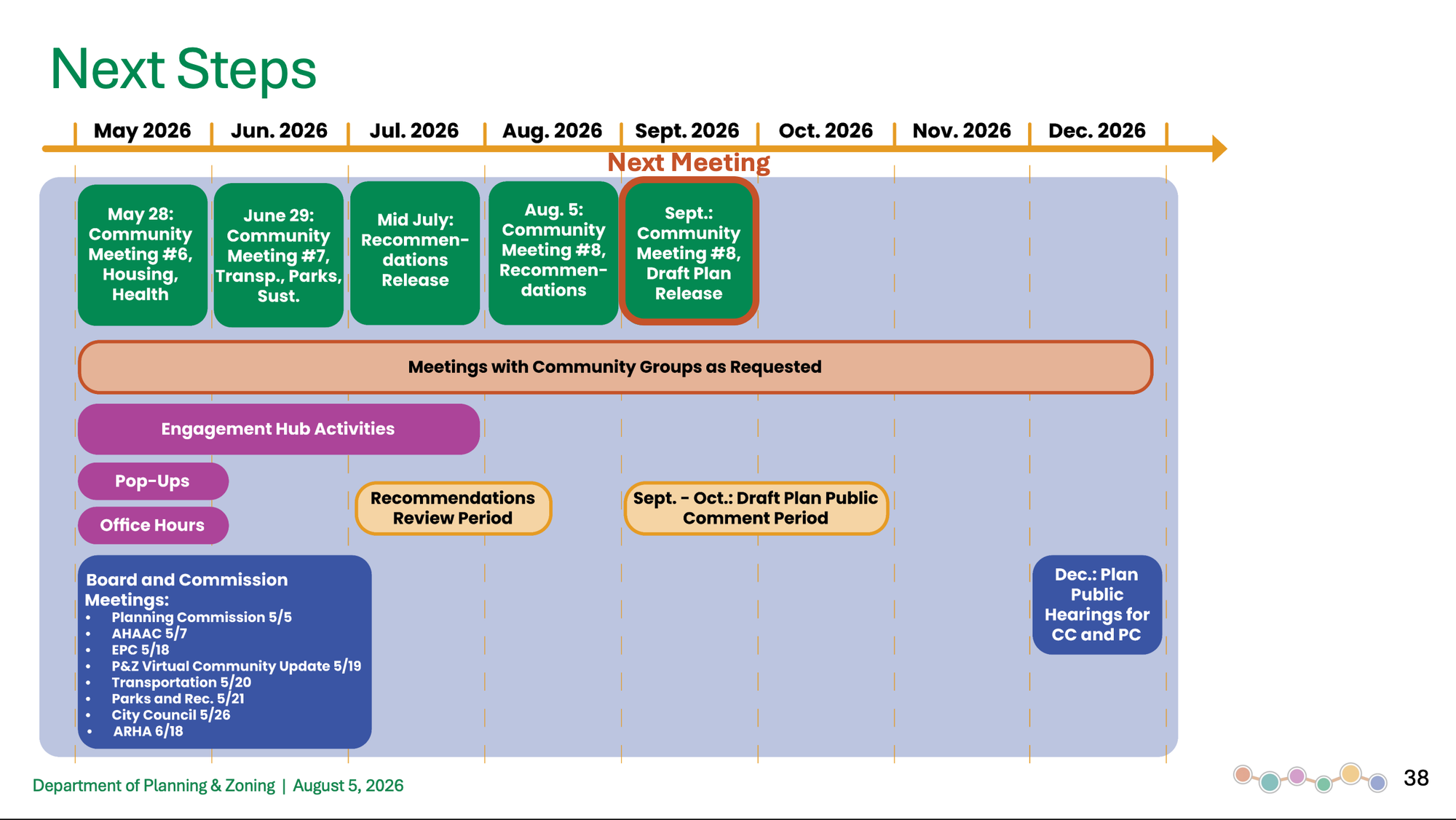
The September draft will include an implementation chapter sorting actions into short-, mid- and long-term phases with associated funding. Most funding will come through redevelopment, Farner said, alongside city investment already underway on the transitway.
Comments can be submitted through the Engagement Hub, by email, or by voicemail. Brandt said he had scheduled a presentation to one condo community for the coming week and will present to others on request. A 30-day comment period follows the September draft release, with Planning Commission and City Council hearings scheduled for December.
The presentation from Wednesday's meeting, a written Q&A and the English-language recording are posted on the project webpage, along with Spanish and Amharic recordings.